|
Europe at the Beginning of December 1941
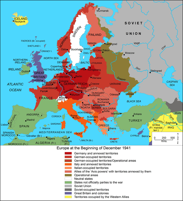
This map shows the territorial and political situation of Europe in December 1941, more than two years after the beginning of the Second World War. At that point in time, the territory occupied by Germany and its allies stretched from the western coast of France to the Black Sea. In the north, Denmark and Norway had been occupied; in the south, Germany and the Axis Powers had managed to advance as far as Crete. After a series of “Blitzkriege,” Hitler had succeeded in extending his power to virtually the entire European continent. After the invasion of Poland in 1939, German armed forces conquered Denmark, Norway, the Netherlands, Belgium, and France, in quick succession. After the signing of Franco-German Armistice on June 22, 1940, France was divided in two: the northern portion of the country was under German occupation, while the southern portion of the country was governed by the collaborationist Vichy Regime. In early March/April 1941, Yugoslavia and Greece were also occupied, and German troops cooperated with Italian forces in the Mediterranean area, above all in Northern Africa. The state of Yugoslavia was dissolved; the state of Croatia was founded. Success eluded Hitler only in the air war against England. On June 22, 1941, the Wehrmacht invaded the Soviet Union, registering initial successes there. That same month, Romania joined the war on the side of the Axis Powers. In the southern part of the Soviet Union, Ukraine was occupied; in the northern part, the Baltic states. On December 5, 1941, Estonia became the last Baltic state to be incorporated into the "Reich Commissariat Ostland". It remained an operational area for the army, however, which is why it is marked both as an occupied territory and an operational area in this map. After Japan launched a surprise attack on the U.S. at Pearl Harbor, Hitler kept a promise he had made to the Japanese government and declared war on the U.S. in December 1941. Germany and its allies were now fighting in Russia, the Balkans, Africa, and on the oceans against the Allied forces of America, England, the Soviet Union, and the French government in exile. Please click on print version (below) for a larger version with enhanced resolution.
Cartography by Mapping Solutions, Alaska.
Source: "Europe at the Beginning of December 1941," in Germany and the Second World War, edited by the Research Institute for Military History, Potsdam, Germany. Volume IV, The Attack on the Soviet Union, by Horst Boog, Jürgen Förster, Joachim Hoffmann, Ernst Klink, Rolf-Dieter Müller, and Gerd R. Ueberschär. Clarendon Press: Oxford, 1998.
|


 print version
 return to map list
 previous map