INTRODUCTION | DOCUMENTS | IMAGES | MAPS | EDITOR
|
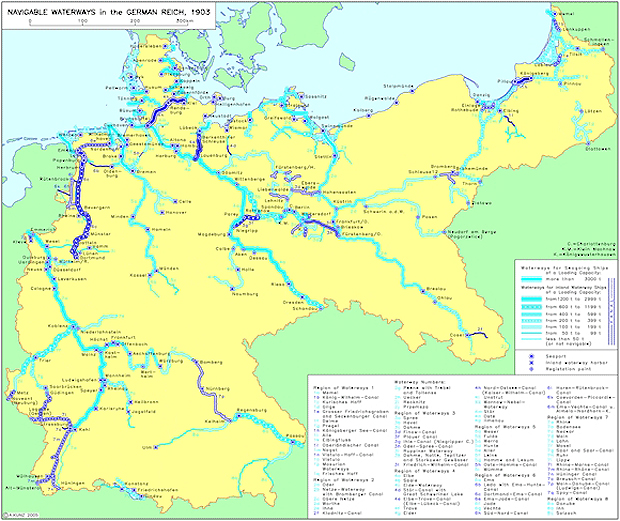
After getting off to a slow start, Prussia, with its strong agrarian interests, went on to become especially active in canal construction. In 1906, after several failed attempts, the Prussian Diet finally passed a bill allowing for the construction of canals between the Rhine and the Dortmund-Ems Canal, between the Dortmund-Ems Canal and the Weser River, and between Berlin and Stettin. It also provided for the canalization of the Oder River between the Glatzer Neisse River and the city of Breslau. The Prussian legislature simultaneously passed a resolution urging the Reich government to introduce bills for the canalization of the Moselle, Lahn, and Saar Rivers in the western territory of the Reich, and for the construction of the Masuric Canal in East Prussia. But Prussia was not alone in this flurry of construction: at the same time, the Württemberg government ordered the construction of a canal from the Rhine via the Neckar to the Danube (at Lauingen), so that goods could be transported from the Near East and the Black Sea to the North Sea at minimal cost.
While the expansion of inland waterways proved economically beneficial, particularly to the rural members of Germany’s rapidly growing populace, its negative effects on the environment did not go unnoticed. The regulation of rivers, the clearing of their banks, and other measures taken to make waterways more efficient deprived surrounding lands of their natural protection against flooding. Moreover, increasing steamship traffic on major rivers, especially the Rhine, caused concerns about air pollution. The negative results of the expansion of inland waterways were debated in the Prussian Diet as early as 1881.
Please click on print version (below) for a PDF file with enhanced resolution. This file is best viewed at 200-300%.
IEG-Maps, Institute of European History, Mainz / © A. Kunz, 2004 |
 print version
 return to map list