GHDI logo


Berlin (1961)

This map shows the impact of the building of the Berlin Wall on August 13, 1961. Initially, the Wall sealed off the Soviet sector of the city (i.e., East Berlin) from the three Western sectors (West Berlin). (Over time, another wall was built to secure West Berlin's external border with the GDR.) The Wall immediately interrupted the movement of citizens between the eastern and western parts of the city. (Until that point, such movement had proceeded with relatively few restrictions.) Moreover, after the Wall was built, only seven of the former 80 checkpoints on the city's internal border remained in place. One of them was reserved for foreign nationals and became known throughout the world as Checkpoint Charlie. Two additional checkpoints were reserved for citizens of the Federal Republic, and four border crossings were designated for Berliners from the western part of the city. Somewhat later, the subway [U-Bahn] and suburban train [S-Bahn] station Friedrichstraße was added as a crossing. (It is not shown on this map.)

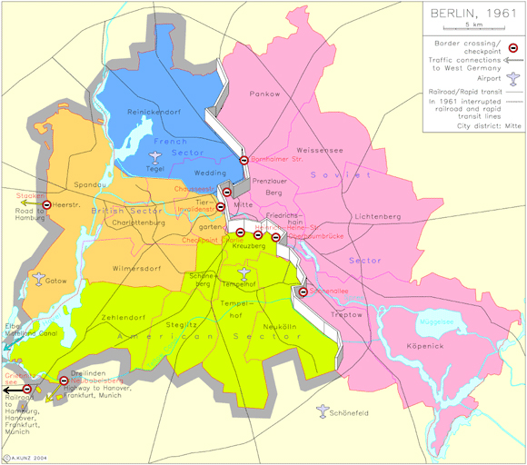
While the city's internal road and railway links were severely disrupted by the building of the Berlin Wall, they were not totally crippled at first. Suburban train traffic between the western and eastern parts of the city ceased entirely, as did traffic between Berlin's environs and West Berlin, but the subway line running through East Berlin on a north-south axis continued to operate. It made only one stop, however, in East Berlin – at the heavily guarded Friedrichstraße station. Long-distance travel to the Federal Republic (via road, railway, and canal) proceeded without interruption via the checkpoints indicated on the map.

Please click on print version (below) for a larger version with enhanced resolution.

print version     return to map list previous map      next map

Berlin (1961)

IEG-MAPS, Institute of European History, Mainz / © A. Kunz, 2004