INTRODUCTION | DOCUMENTS | IMAGES | MAPS | EDITOR
|
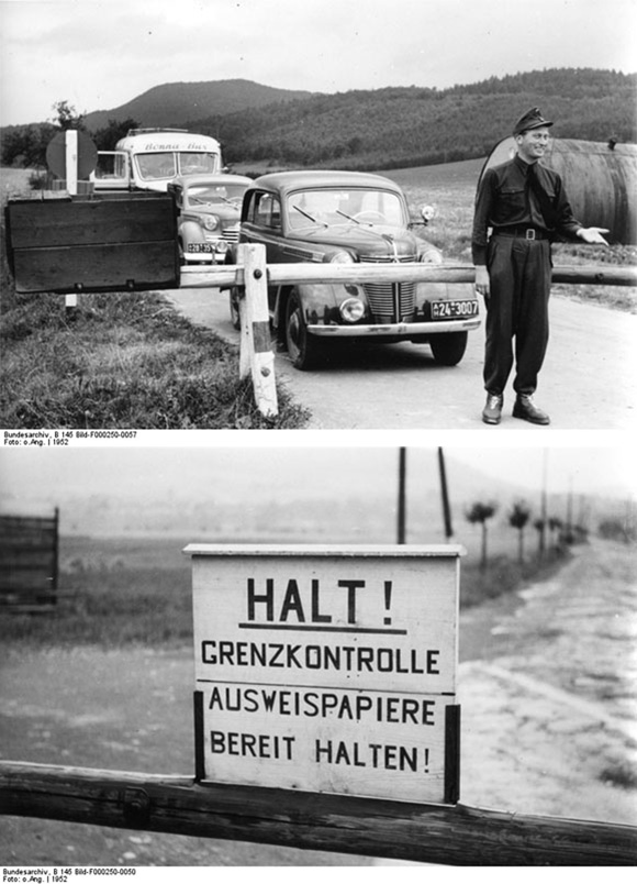
On May 23, 1949, the Federal Republic of Germany was founded on the territory of the American, British, and French occupation zones. After the merging of these three zones, the only remaining sections of the old zonal borders were the ring-shaped border separating West Berlin – a virtual island – from the surrounding Soviet occupation zone and the 1,400-kilometer long border from the Baltic Sea to the Ore Mountains [Erzgebirge] separating the newly founded Federal Republic from the Soviet occupation zone. After the founding of the GDR on October 7, 1949, that border became the dividing line between East and West Germany. After the Western occupying powers rejected the 1952 “Stalin Note,” the government of the GDR issued the “Decree on Measures regarding the Demarcation Line between the German Democratic Republic and the Western Occupation Zones of Germany” (May 26, 1952), which called for the sealing and fortification of the inner-German border. A five-kilometer wide prohibited area [Sperrzone] was established along the entire border. This area included a 10-meter wide control strip, which was cleared, plowed, and partially planted with mines or outfitted with spring guns; a 500-meter wide protective strip, which was cleared and secured with barbed wire in many places; and finally a zone where carrying identification was required. It was all but impossible to enter the control and protective strips, and passage through the remaining portions of the prohibited area was governed by special regulations. Residents needed to have a special notation on their personal ID in order to gain passage and visitors needed an entry pass, which was normally denied to foreigners. After the establishment of this “demarcation line,” the only remaining option for would-be emigrants was the border with West Berlin; after the Berlin Wall was built in 1961, this option no longer existed, and the number of new arrivals from the GDR dropped dramatically.
© Bundesarchiv |
 print version
 return to image list
 previous image