INTRODUCTION | DOCUMENTS | IMAGES | MAPS | EDITOR
|
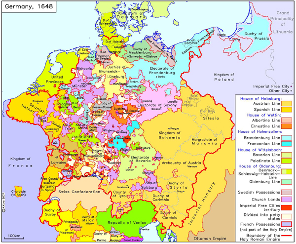
The peace treaties stipulated some important territorial changes. They recognized the Swiss Confederation and the Dutch Republic as autonomous states, though the southern (Spanish) Netherlands remained part of the Holy Roman Empire. France and Sweden made out the best. France acquired most of Alsace on the Upper Rhine, while Sweden got Western Pomerania and Bremen, making it a German territorial power with a seat and vote in the Imperial Diet [Reichstag]. The war in Europe had allowed both states to augment their power considerably. Bavaria kept the Upper Palatinate and the Palatine electoral office, both of which it had acquired after Catholic victories in the first half of the 1620s. The Count Palatine, who had lost that office, received a new electorate, giving the electoral college eight instead of seven votes. As for other gains, Electoral Saxony received Lusatia, formerly a Bohemian crown land, while Brandenburg got Eastern Pomerania and several episcopal territories. Central Germany remained a zone of extreme territorial fragmentation. The Habsburg and Hohenzollern dynasties ruled substantial regions located outside of the Imperial borders, the former in the kingdoms of Bohemia and Hungary, the latter in Prussia. The peace treaties of 1648 placed further restrictions on the emperor’s powers by making them contingent upon the Imperial Diet’s consent, and the Imperial princes were given the right to enter into alliances with other powers. The post-1648 Empire remained a confederation of states lacking centralized organs of government or a standing army.
Please click on print version (below) for a PDF file with enhanced resolution. This file is best viewed at 200-300%.
IEG-Maps, Institute of European History, Mainz / © A. Kunz, 2007 |
 print version
 return to map list
 previous map