|
The German Empire (1871-1918)
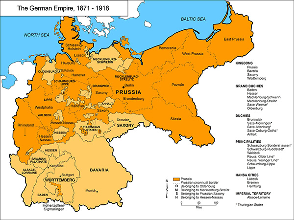
It is often forgotten that the German Empire [Reich] comprised no fewer than 26 territories, each of which maintained a modicum of sovereignty. Hence the term “empire” makes sense. The degree of independence enjoyed by each federal state nevertheless depended on many factors, including not only its geographical size, depicted here, but also its population, economy, political system, administrative structure, and dynastic traditions. Prussia was something more than just primus inter pares in the federal empire: it constituted 64 percent of Germany’s territory and 61 percent of its population (in 1890). Many individual Prussian provinces were much larger than other federal states. But the kingdoms of Bavaria, Saxony, and Württemberg, together with the Grand Duchy of Baden, all exerted considerable influence in Reich affairs, and distinctive regional identities persisted even as a common sense of “Germanness” gradually took hold in the decades after unification. Between 1871 and 1890 Germany’s total population rose from about 41 million to about 49 million; by the First World War it had reached about 68 million. Please click on print version (below) for a larger version with enhanced resolution.
© German Historical Institute, Washington, DC / James Retallack, 2007.
Cartography by Mapping Solutions, Alaska.
|


 print version
 return to map list
 previous map